A TRAPPER’S TRAIL by Barney Moorhouse
Life is like a puzzle. The more pieces one can fit together the clearer the picture. It is such interconnection that often makes history interesting. It becomes multi-dimensional. Such was the case when I was discussing the Havelock bank robbery with Layne Moore of The Ridge. Moore told me of the first murder in the area, a trapper, in the 1800’s. A little sketchy on detail he said that he had a book that told all about it. Months later, Moore found that book.
“Way Back When (WBW)….” appears to have been authored by Garnet Pigden and Ardith McKinnon during the summer of 1975 with thanks to a federal government Opportunities For Youth Grant. Although the book’s focus featured Madoc Village and Madoc Township Layne Moore directed me to “The Murder of Robert Donald Dickey,” which, if I have my geography correct, is in Lake Township. (If I don’t I’m sure some good Samaritan will enlighten me.)
Anyone who has tried to back track the trail of ancestors will relate to misspelled names. As was explained to me, once the clerk recorded a name that became THE established spelling. While searching further I came across the informative website of Dickey Lake (DL) which added more pieces of the puzzle. Information on that website was provided by George Thompson, Grant Boundy, Helen McPherson and Chris Bird (from California).
And so Robert Donald Dickey (WBW), correctly spelled “Dickie” (DL), was born July 28, 1825 in Cherry Dale (WBW), or Cherryvale (DL), Aberdeen, Scotland to John and Isabel Dickie. Commonly called Donald, Dickie traveled to Australia where rumour has it he acquired some gold. McPherson disputes the gold theory believing Dickie’s rich father grub-staked him. Apparently he disliked Australia and so Dickie emigrated to Canada in the 1850s (DL). During the years 1858-1872 the government offered 100 acre lots to any pioneer on the condition that he build a residence and clear 3 acres of tillable land within 3 years. If the pioneer met the challenge he then received the deed.
During this time Donald’s older brother George was making a name for himself as a medical doctor and research Botanist in Scotland. In 1849, George went to Ireland where he was appointed chair of natural history at Queen’s University where he assisted Charles Darwin (Yes, THE Charles Darwin) with a book on the fertilization of orchids.
Initially, like so many other trappers, Donald Dickie built a smaller temporary shelter and enlisted the help of a carpenter named Barbeau to build a more suitable cabin on the east side of the Hastings Road opposite the current Thompson property.
“Samuel Peter Rock had the brand of the Townsend Gang,” (WBW). Apparently this gang operated in the Buffalo, St. Catherines and Fort Erie areas. “When the gang was broken up, Rock escaped to Canada. He was nearly freezing to death when Dickey took him in and gave him the mitts off his own hands.” (WBW). Perhaps Rock had heard the rumour of Dickie’s gold while working for him. It seems, according to DL, that the local population knew about the rumoured gold. Returning, unexpectantly to his new cabin, Dickie and Barbeau surprised Rock who was going through Dickie’s Australian chest – presumeably in search of his wealth. While exclaiming, “My God, I’m robbed,” Rock pulled out a muzzle loader and shot Dickie in the neck, at point blank range, killing him. Barbeau escaped to the shore of Dickey Lake and continued to the homes of the Henderson’s and Murphey’s. The DL version states that Barbeau was joined by Pat (Paddy) Nugent, Charlie Murphy Sr., and John Thompson (George Thompson’s grandfather). The WBW version said that Rock was caught in an old barn; the DL version said he was found staying at a hotel owned by Sandy Menzie, located north of Murphy’s Corners towards the Village of Ormsby. They debated hanging Rock on the spot but decided to let justice prevail. According to WBW there were no policemen in the area so Martin Murphy was sworn in as a special constable and Charles Murphy as deputy sheriff to take Rock to Belleville by horse and buggy. There was no mention as to who did the “swearing in.”
Samuel Peter Rock was tried, convicted and ultimately hanged on June 13, 1859. There is a discrepancy in dates between the sources. The DL version said Rock killed Dickie on January 10, 1859; WBW said June 10, 1859. The latter was probably a typo as the one-way trip to Belleville took two days and justice surely wasn’t that fast.
Layne Moore heard that some walked to Belleville to witness the execution. WBW said three men walked to Madoc the first day and on the second walked to Belleville to “make sure that his murderer was hung.” (WBW)
Dickie’s muzzle loader shotgun with a kangaroo engraved on the stock went missing during the intervening years. Rumour has it that Dickie’s gold – if it ever existed – has yet to be discovered and Dickey Lake of course bears his albeit misspelled name.
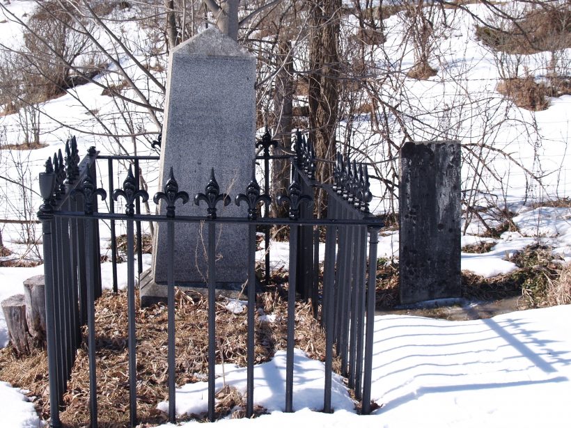
WBW tells us that John Dickie brought the tombstone and iron rails from Scotland for the burial plot in O’Hara’s cemetery. The DL version is more detailed quoting the inscription: “Erected by John Dickie of Cherryvale in Aberdeenshire, NB (New Britain), to commemorate the tragic death of his son, Robert Donald Dickie, born 28 July 1825, who was robbed and murdered in his own house 10 January 1858, by Samuel Peter Rock, one of his own servants who was tried and convicted of the robbery and murder, and executed 13 June 1859.”
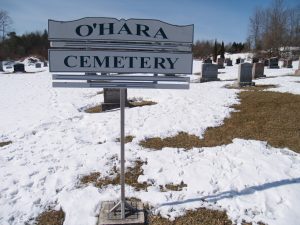
The O’Hara Cemetery, according to the DL version, is located about 1 kilometre west of Highway 62 and north of Highway 7 on the west side of the O’Hara Road. The GPS reading is 18 301427E, 4931670N. The grave plot is surrounded by an iron fence; it and the stone which was sent from overseas by his parents (DL). Evidently the Dickie family was well-to-do since the engraving is expensive and the fence an embellishment not often seen.
I visited the site under a bluebird sky one bright March morning and saw a flock of 16 wild turkey. Evidently, by the tracks in the snow, they spend considerable time among the tombstones. The inscription has worn severely after many years of enduring the elements.
Why was Dickie buried at the O’Hara Cemetery when the Coe Hill Cemetery is so much closer to where he lived and died? According to McPherson, most of the sites in the O’Hara graveyard are of Scottish descent whereas at Coe Hill they are Irish.
According to Layne Moore, Bowes&Cocks of Peterborough changed the name of the area to Shawano (Clear Water and Tall Pines) which covers some 1000 acres for a cottage development which included Dickey Lake, Lost Lake, Perch Lake and Lake of Islands. Way back when…
For those who may need a pit stop Tim Hortons is about 1 km away at the corner of highways 62 and 7.
Photos – O’Hara Cemetery – 3 a. The Dickie tombstone. 3b. Note turkey tracks.